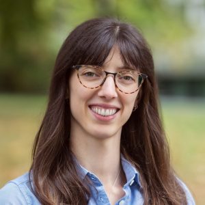
New Faculty Profile: Joséphine Gantois

Dr. Joséphine Gantois combines economics and ecology with tools like machine learning and interviews to study the impact of human actions on biodiversity.
“I started specializing in environmental economics as I became more aware of ongoing environmental issues, and it seemed essential to me to bring natural sciences into the mix,” says Dr.
Gantois, who studies both natural and agricultural landscapes.
Along with the approaches she has gained from studying economics and ecology, Dr. Gantois uses computational tools and remotely sensed data to produce wide-ranging data sets that can inform land use decisions.
“I’m interested in how to take ecological data, which are often unavailable at large scales because of measurement costs, and use remote sensing to scale them up,” explains Dr. Gantois.
Capturing variation at large spatial and temporal scales opens more opportunities for establishing causal impacts.
Prior to joining the Faculty of Land and Food Systems, Gantois was a postdoctoral fellow in UBC’s Institute for Resources, Environment and Sustainability, in a research group led by Professor Claire Kremen, co-appointed in the Department of Zoology.
The research group looked at agricultural areas in Southern Ontario. They interviewed farmers to understand how they dealt with less profitable areas in their fields and whether or not it would be feasible to convert them to semi-natural habitat. This approach was a learning experience for Dr. Gantois who was used to quantitative, computer-based research at the time.
“It takes time to learn how to do these things well: establish relations with organizations and people, build trust, and maintain those relationships.”
These sociological approaches have challenged Dr. Gantois to understand the numerous facets of how a farmer might make decisions about new agricultural practices: the role of economic
factors, the farmer’s environmental objectives, their relationship to the land.
Dr. Gantois explains that she also tries to adopt a land use planning or policy making perspective considering, for example, how individual actions have impacts that spill over to surrounding landscapes and add up to regional effects, which is where satellite data can have a real added value.
“I’m always interested in understanding what each method brings and how you can compare and intersect the knowledge that you get from those different approaches.”
Tagged with: 2023, Faculty, Food and Resource Economics
